Navionics Platinum+ U.S. Southeast & Bahamas SD/microSD
Electronic charts are NOT returnable. When ordering, please write in the comments field the type of GPS unit you will be using this item with. This is to ensure that you are ordering a compatible chart.">
Our Best Offers
Free Economy Shipping on Orders over $100 with NO CODE NECESSARY! (Some Exclusions Apply)
Current Active Promotions
| Model TD Code | Description | Price |
| MSD/906P+ NVN-0076 | Navionics Platinum+ U.S. Southeast & Bahamas SD/microSD | $399.00 USD | |||||||||
The Navionics Platinum+ U.S. Southeast & Bahamas SD/microSD provides free unlimited updates for a year from time of registration.
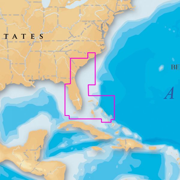
Coverage includes the Southeastern United States and Bahamas, including:
BAHAMAS From Cape Fear to Turks and Caicos Islands to Cedar Keys, including the entire Florida Keys, Dry Tortugas and Cay Sal Bank. Florida from Fort Pierce to Key Largo and Northern Bahamas from Grand Bahama to Long Island. Including Miami, West Palm Beach, Cay Sal Bank, Great Abaco Island, Andros Island, Providence Channel, Exuma Sound, Cat Island.
- Platinum + Charts - The most advanced technology and best imaging available in multi-dimensional charts
- Improved 3D View - With enhanced bottom contour profiles and high-resolution photo overlay
- Contiguous Satellite Photo Overlay - The best available high-resolution top-down satellite and aerial photo overlays
- Allows comparison with chart information improving situation awareness
- Helps anglers find the skinniest of water not available on any electronic chart
- Brilliant Panoramic Pictures - Harbors, marinas, ports and passes in full-view XGA
- Enhanced Port Services - Access detailed information, including phone numbers, for services and points-of-interest available near port
- Plus major coastal road networks to help you find your way from port to points-of-interest
- Complete NOAA Coast Pilot - Volumes of available navigation information such as channel and wharf descriptions, anchorages and bridge clearances, all geo-referenced to your current position
- Tides & Currents - Access tidal heights, flow speed and direction, for today's fishing trip or next week's cruise down the coast
- Compatible Humminbird Plotters: 955C, 957C, 967C 3D, 997C SI, 1197C SI, 1157C, 1155C
- Compatible Lowrance Plotters: HDS-10/HDS-10M, HDS-8/HDS-8M, HDS-7/HDS-7M, HDS-5/HDS-5x/HDS-5M
- Sonar Live Charting
- The micro SD card is not marked "Navionics" so when you pull it from your plotter it is easily confused with your other micro sd cards.
Show off your fishing gear investment. Please post images and videos of your fishing gear, apparel, catches and lifestyle shots on and off the water. Let's see what you've got for a chance to win FREE gear! You can use #HookedOnTD or UPLOAD YOUR IMAGE HERE to make it onto our product pages or gallery. See something you like? You can shop directly from the images we post when gear we sell is featured!


