Our Best Offers
Free Economy Shipping on Orders over $100 with NO CODE NECESSARY! (Some Exclusions Apply)
Current Active Promotions
| Model TD Code | Description | Coverage | Price |
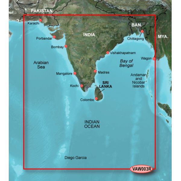
| VAW003R GRM-1639 | BlueChart g2 Vision | Indian subcontinent from Pasni, Pak., to Sandoway, Myan Indian cities of Mangalore, Quilon, and Calcutta general coverage of Sri Lanka, the Andaman and Nicobar Islands the Chagos Archipelago, and the Maldives detailed coverage of the Male Atoll | $249.99 USD | ||||||||
General coverage of the Indian subcontinent from Pasni, Pak., to Sandoway, Myan. Included in this overall general coverage are a number of detailed charts covering areas such as the Indian cities of Mangalore, Quilon, and Calcutta. Also includes general coverage of Sri Lanka, the Andaman and Nicobar Islands, the Chagos Archipelago, and the Maldives, except for the detailed coverage of the Male Atoll.
Garmin BlueChart g2 Vision has set the industry standard in premier electronic chartplotter-based marine charting. BlueChart g2 Vision offers the high detail charting of BlueChart g2 plus high-resolution satellite imagery, above and below water 3-D perspective, auto guidance technology, aerial photographs for real world reference, and coastal roads with points of interest.
Enable the full functionality of Garmin's new line of chartplotters - the GPSMAP 5XXX series, the GPSMAP 4XXX series, the GPSMAP 5X5 series, the GPSMAP 5X0 series and the GPSMAP 4X0 - with the addition of a BlueChart g2 Vision SD card.
BlueChart g2 Vision SD cards provide:
- High-resolution satellite imagery when, overlaid on the chart, will provide the mariner with unparalleled situational awareness
- Aerial reference photography provides "real world" photos of ports, harbors, marinas, waterways, navigation landmarks and other points of interest, offering the mariner another powerful tool for navigating unfamiliar waters
- Mariner's Eye view - Provides the mariner with a 3-D perspective of chart information for a quick, reliable and easy position fix
- Fish Eye view - 3-D perspective below the water line for displaying bottom contours based on bathymetric charting data
- Auto guidance technology will search chart attributes to suggest the best passage to a destination
- Fishing charts, tides, currents, marine services, coastal roads and points of interest detail
- Detailed charting is included on the card for those customers who have purchased units without preloaded detailed charting, or who will be traveling outside of the areas covered on units with preloaded detailed charting
Compatible with: GPSMAPs 5212, 5208, 5012, 5008, 4212, 4208, 4012, 4008, 545(s), 540(s), 535(s), 530(s), 525(s), 520(s), 440(s), 430(s), 420(s).
Show off your fishing gear investment. Please post images and videos of your fishing gear, apparel, catches and lifestyle shots on and off the water. Let's see what you've got for a chance to win FREE gear! You can use #HookedOnTD or UPLOAD YOUR IMAGE HERE to make it onto our product pages or gallery. See something you like? You can shop directly from the images we post when gear we sell is featured!


 WARNING: This product can expose you to chemicals which are known to the State of California to cause cancer, birth defects or other reproductive harm. -