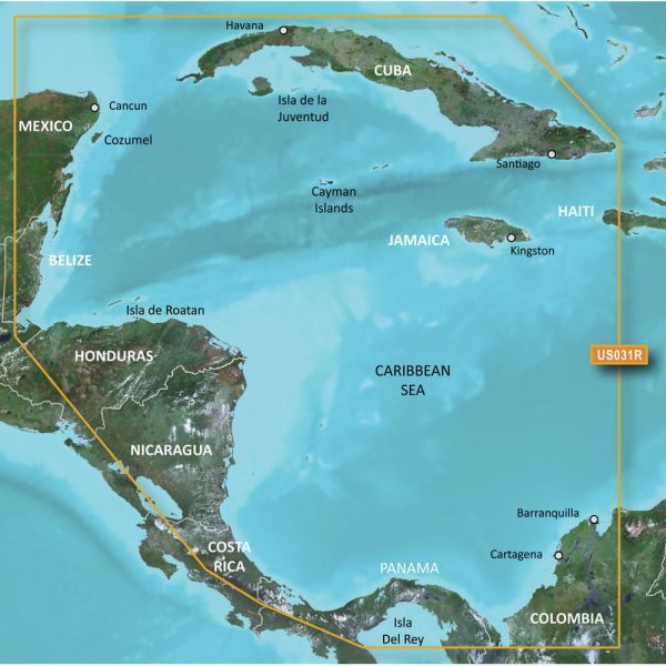
Garmin 010-C0732-20 Bluechart G2 HXUS031R Southwest Caribbean microSD/SD Card
Our Best Offers
Free Economy Shipping on Orders over $100 with NO CODE NECESSARY! (Some Exclusions Apply)
Current Active Promotions
| Model TD Code | Description | Coverage | Media | Price |
| 010-C0732-20 GRM-0618 | BlueChart g2 HD | Southwest Caribbean | microSD/SD | $149.99 USD | |||||||
The Garmin 010-C0732-20 Bluechart G2 Southwest Caribbean microSD/SD Card provides detailed coverage of the northern coast of Central America all the way from Cancun, Mexico to Barranquilla, Colombia, and including the Panama Canal in its entirety. Also includes General coverage of the northern half of the Gulf of Panama and detailed coverage of the coasts of Jamaica, Cuba, and the entirety of the Caymans.
Garmin 010-C0732-20 Bluechart G2 Southwest Caribbean microSD/SD Card Features:
- Up to 1-foot HD fishing contours
- Vector object-oriented data
- Seamless chart presentation
- Shaded depth contours and intertidal zones with spot soundings
- 2-D or 3-D map perspective view
- Port plans
- Tidal stations for selected countries
- Wrecks, restricted areas, anchorages, obstructions
- Aids to navigation with view range and coverage, including light sectors information
- Marina points of interest and slipways
- Full bathymetric fishing charts providing detailed contours
- Tidal current graphs
See your vessel's precise position on-chart in relation to navaids, coastal features, spot soundings, port plans, waterways, anchorages, obstructions, restricted areas and more. BlueChart g2 HD provides seamless chart presentation with 1-foot HD contours to provide a more accurate depiction of bottom structure for improved fishing charts and navigation in swamps, marinas, canals, and port plans. Coverage is available worldwide in regional offerings for Garmin handhelds and chartplotters.
Improve your view with 1-foot HD contours- Detailed nautical charts derived from government charts and private sources to provide port plans, depth contours, navigational aids, and tides and currents in a seamless chart presentation
- Shaded depth contours and intertidal zones with spot soundings
- Vector object oriented data
- 1-foot HD contours provide a more accurate depiction of bottom structure for improved fishing charts and navigation in swamps, canals and port plans
- Worldwide coverage available in regionalized cuts
Show off your fishing gear investment. Please post images and videos of your fishing gear, apparel, catches and lifestyle shots on and off the water. Let's see what you've got for a chance to win FREE gear! You can use #HookedOnTD or UPLOAD YOUR IMAGE HERE to make it onto our product pages or gallery. See something you like? You can shop directly from the images we post when gear we sell is featured!


 WARNING: This product can expose you to chemicals which are known to the State of California to cause cancer, birth defects or other reproductive harm. -