Our Best Offers
Free Economy Shipping on Orders over $100 with NO CODE NECESSARY! (Some Exclusions Apply)
Current Active Promotions
| Model TD Code | Description | Price |
| 010-01017-21 GRM-1696 | GPSMAP 8212 - 12'' Multifunction Display Only - U.S. Coastal Charts | $4,255.99 USD | |||||||||
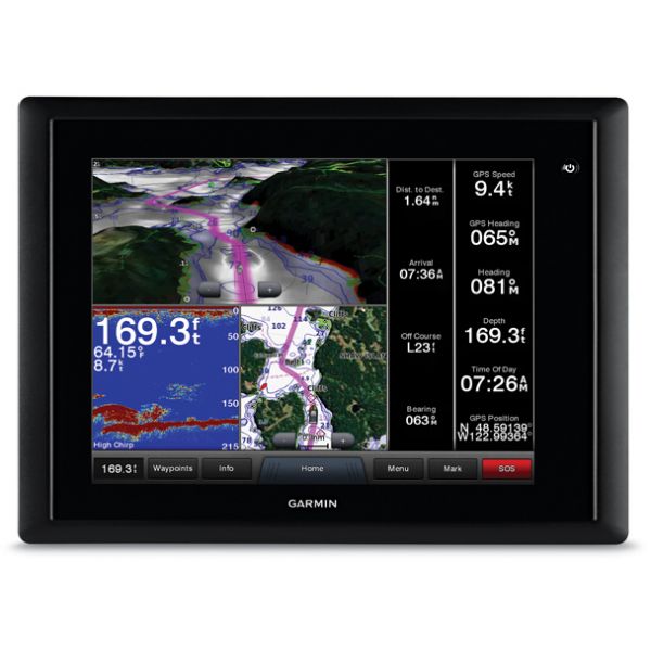
When only the best will do, the Garmin GPSMAP 8000 series is for you. The ultimate in glass-helm technology, this multi-touch multi-function display can handle all your needs on the water. This Garmin GPSMAP 8012 boasts a 12" diagonal screen with pre-loaded BlueChart g2 (United States Great Lakes, Atlantic Coast, Gulf Coast and Pacific Coast) and is best used as a second station or an addition to another setup. Customize your system based on your needs: in addition to GPS, there are sonar, radar, satellite weather modules, and more!
More Features and Specifications
Multi-touch Glass Helm Display
The bright, crisp touchscreen comes standard with preloaded BlueChart g2 maps of the U.S. coast and includes pinch-to-zoom and other touch controls to give you intuitive finger-tip operation. Anti-glare and LED backlighting makes this series the easiest to view in bright sunlight; auto-dimming provides outstanding visibility at night.
Full System Integration
Integrates everything, including various sonar technologies, integrated autopilot, connectivity, apps, engine data and multi-media. SmartMode control allows the user to quickly change all screens at a helm in sync to a preset mode. Everything you need is at the tip of your finger, all on one screen.
Customize Layouts with SmartMode Control
SmartMode control allows you to switch all monitors in sync from one mode to another without manually switching each monitor separately. Fully customizable layouts, data and gauges allow you to place the information you need to see right where you want it.
Includes BlueChart g2
BlueChart g2 marine maps feature crisp labeling and an overall smooth presentation on your chartplotter display. In addition to the basic charts, tidal stations, currents, depth contours, IALA symbols and included fishing charts, BlueChart g2 offers smooth transitions between zoom levels and seamless continuity across chart boundaries. Covered by the exclusive New Chart Guarantee. Main coverage includes the United States East Coast, West Coast, Gulf Coast and Great Lakes, as well as some detail for Alaska, Hawaii and the Bahamas.
GRID (Garmin Remote Input Device)
A remote device that provides full control of all GPSMAP 8000 Glass Helm series units. Rotary knob and joystick controls provide navigation through menus and screens and allows you to seamlessly navigate between monitors at a station. Control single or multiple monitors with one device. Supports multiple devices per station. Small footprint can be integrated into a captain's chair (sold separately.).
Flexible Mounting Options
The 8212 MFD is compatible with the traditional bail mount, or you can step up to the low-profile flush mount. For the ultimate in custom appearance, check the the exclusive flat-mount glass helm option.
What's In the Box:
- GPSMAP 8212 with BlueChart g2 United States Coastal coverage
- Bail mount and knobs
- Protective cover
- Flush mount gasket and hardware
- Power cable
- NMEA 0183 cable
- NMEA 2000 2 m backbone/drop cable
- NMEA 2000 10 m backbone cable
- NMEA 2000 power cable
- NMEA 2000 T-connector and terminator kit
- Manual case with documentation
Technical Specifications
Physical & Performance
- Unit dimensions, WxHxD: 13.1" x 9.7" x 3.8" (33.2 x 24.7 x 9.6 cm)
- Display size, WxH: 9.7" x 7.3", 12.1" diagonal (24.6 x 18.4 cm, 30.7 cm diagonal)
- Display resolution, WxH: 1024 x 768 pixels
- Display type: Touchscreen XGA display (anti-glare finish)
- Weight: 11.4 lb (5.2 kg)
- Waterproof: Yes (IPX7)
- Receiver: 10Hz High Sensitivity
- Antenna: External only
- Mounting options: Bail, Flat, or Flush
Power consumption
- Max power usage at 10 Vdc: 35 W
- Typical current draw at 12 Vdc: 1.6 A
- Max current draw at 12 Vdc: 3.5 A
Maps & Memory
- Preloaded maps: BlueChart g2 coastal maps including U.S. Atlantic Coast, Pacific Coast, Gulf Coast, Great Lakes
- Accepts data cards: 2 SD cards (Garmin Card Reader required, sold separately.)
- Waypoints: 5,000
- Routes: 100
- Track log: 50,000 points; 50 saved tracks
- Features & Benefits
- Garmin Radar compatible: Yes
- Garmin Sonar compatible: Yes (with optional GSD black box sonar, sold separately.)
- NMEA 2000 compatible: Yes
- NMEA 0183 compatible: Yes
- Garmin Marine Network compatible: Yes
- Garmin SmartMode compatible (customizable monitor presets): Yes
- Supports AIS (tracks target ships position): Yes
- Supports DSC (displays position data from DSC-capable VHF radio): Yes
- Tide tables: Yes
- Garmin Meteor Audio System compatible: No
- Supports Fusion Lync compatible marine radios: No
- GSD Black Box sonar support: Yes
- GCV Black Box sonar support: No
- SiriusXM Weather & Radio compatible: Yes
- BlueChart Mobile (planning) compatible: Yes (Wi-Fi Adapter Kit required, sold separately.)
- Garmin Helm compatible: Yes (Wi-Fi Adapter Kit required, sold separately.)
- GRID (Garmin Remote Input Device) compatible: Yes, sold separately.
Connections
- NMEA 0183 input ports: 4
- NMEA 0183 output ports: 2
- Video input ports: 2 - BNC Composite
- Video output ports: 1 - DVI-I
- Wireless connectivity: Yes (Wi-Fi Adapter Kit required, sold separately.)
- Garmin Marine Network ports: 4
Show off your fishing gear investment. Please post images and videos of your fishing gear, apparel, catches and lifestyle shots on and off the water. Let's see what you've got for a chance to win FREE gear! You can use #HookedOnTD or UPLOAD YOUR IMAGE HERE to make it onto our product pages or gallery. See something you like? You can shop directly from the images we post when gear we sell is featured!


