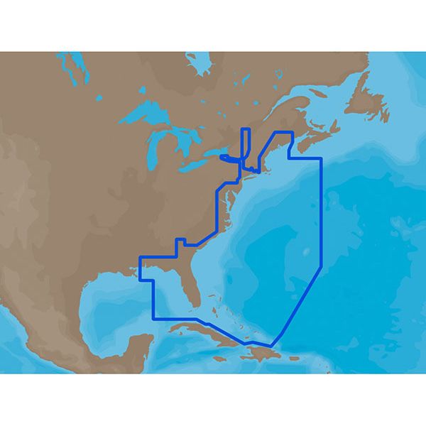
C-Map MAX Electronic Marine Charts - Eastern United States
Our Best Offers
Free Economy Shipping on Orders over $100 with NO CODE NECESSARY! (Some Exclusions Apply)
Current Active Promotions
| Model TD Code | Description | Coverage | Format | Price |
| NA-M022C-CARD CMP-0006 | C-MAP MAX Electronic Chart | U.S. East Coast & The Bahamas | C-Card | $279.00 USD | |||||||
| NA-M022SDCARD CMP-0021 | C-MAP MAX Electronic Chart | U.S. East Coast & The Bahamas | SD-Card | $279.00 USD | |||||||
| NA-M320C-CARD CMP-0014 | C-MAP MAX Electronic Chart | Passamaquoddy Bay ME-NC: Bathy | C-Card | $279.00 USD | |||||||
| NA-M320SDCARD CMP-0029 | C-MAP MAX Electronic Chart | Passamaquoddy Bay ME-NC: Bathy | SD-Card | $279.00 USD | |||||||
| NA-M321SDCARD CMP-0030 | C-MAP MAX Electronic Chart | Cape Henry, NC - Apalachicola, FL | SD-Card | $279.00 USD | |||||||
| NA-M026C-CARD CMP-0010 | C-MAP MAX Electronic Chart | Great Lakes & The Maritimes | C-Card | $279.00 USD | |||||||
| NA-M026SDCARD CMP-0025 | C-MAP MAX Electronic Chart | Great Lakes & The Maritimes | SD-Card | $279.00 USD | |||||||
| NA-M023C-CARD CMP-0007 | C-MAP MAX Electronic Chart | U.S. Gulf Coast & Inland Rivers | C-Card | $279.00 USD | |||||||
| NA-M023SDCARD CMP-0022 | C-MAP MAX Electronic Chart | U.S. Gulf Coast & Inland Rivers | SD-Card | $279.00 USD | |||||||
| NA-M420SDCARD CMP-0031 | C-MAP MAX Electronic Chart | Gulf of Mexico: Bathy | SD-Card | $279.00 USD | |||||||
CMAP MAX Electronic Charts Key Features:
Dynamic NavAids include detailed information on navigational aids, including name, color, information on frequency, range of the light, etc.
Dynamic tides and currents predict the time, level, direction and strength of currents and tides.
Guardian Alarm performs an automatic forward-scanning check for obstacles. Use this feature as an added backup to alert you if you head toward a potentially harmful object.
Photos and diagrams in high-definition of ports, marinas and significant navigational marks will help you to familiarize yourself with new destinations and passages.
Route-check is an extension of Guardian Alarm, helping keep you safe by indicating obstacles along the segments between waypoints.
Depths and land elevation show the usual depth information and the colors make it easy to distinguish different water depths and land elevations.
Detailed harbor charts so docking in unfamiliar ports is no problem. You have precise layouts of thousands of marinas, including slip spaces, restricted areas and other valuable navigation information.
Perspective view gives a bird's-eye view of your navigation area, it tilts the chart view to a 45-degree angle.
C-Marina Port Database has details on more marinas than other charts on the market. Displays harbor hours, harbor master contact info, nearby lodging and restaurants, VHF call-in details, photos and more.
Points of interest (PO Is) and road mapping helps whether you're looking for a restaurant or museum, you can find it in our extensive database of local services and cultural highlights.
Multi-language capability – All C-MAP by Jeppesen charts can be displayed in both English and the local language of each region. More than 140 languages are available.
Show off your fishing gear investment. Please post images and videos of your fishing gear, apparel, catches and lifestyle shots on and off the water. Let's see what you've got for a chance to win FREE gear! You can use #HookedOnTD or UPLOAD YOUR IMAGE HERE to make it onto our product pages or gallery. See something you like? You can shop directly from the images we post when gear we sell is featured!


